Why Old Streets Rarely Make a Perfect Grid
Why old streets rarely make a perfect grid: learn to read bends, junctions and route changes without mistaking one street shape for proof of history.
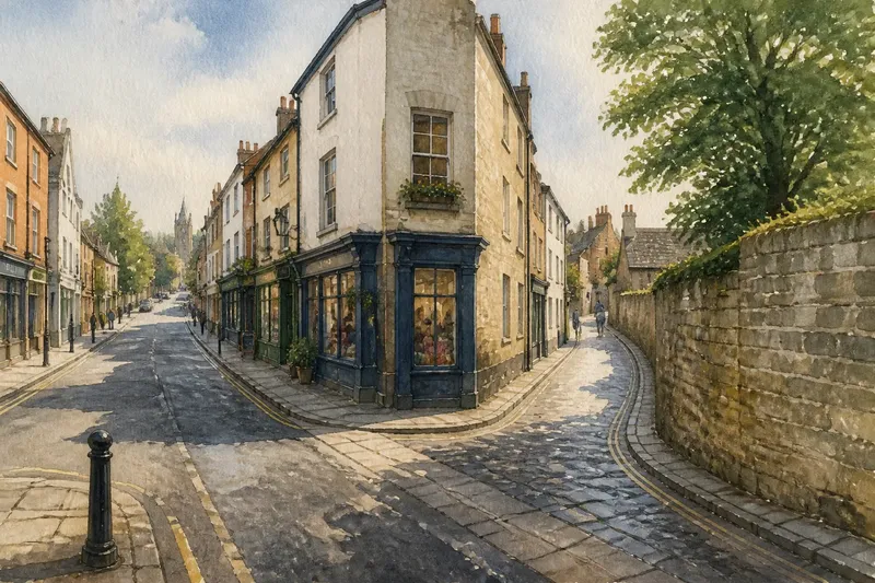
At a junction, one street runs straight while the next slips away at an angle, squeezed between a row of shops and a stone wall. Why old streets rarely make a perfect grid becomes easier to see on foot: today’s route may carry traces of earlier paths, later boundaries and changing uses, all without offering a simple story.
A bend is a clue to inspect, not a historical label. Read it alongside the ground, neighbouring streets and the places the route connects. These short field notes offer a way to notice patterns while keeping the evidence and the guesswork separate.
What does a crooked route connect?
Pause where a street changes direction and look beyond the nearest corner. Does it continue towards a bridge, a station, a river crossing or a gap in a wall? Does it meet a busy road at an angle that makes walking feel natural? A street’s present-day connections can help explain why its route matters now, though they do not by themselves reveal when or why it first formed.
On a folded paper map, trace the street in both directions. Then check a current map on your phone. The older street may appear to align with a route that modern development has partly hidden, or its present junctions may simply reflect later changes. Record the visible relationship before deciding what it might mean.
Field note: Write down the places connected by the bend, not just the bend itself. “Turns towards the river crossing” is an observation. “Built for river traders” is a historical claim that needs other evidence.
Could an older path have shaped it?
Many streets have accumulated uses. A route might have begun as a footpath, served local movement, and later become a street lined with buildings. A road could also have been laid out as a planned route and then altered as the district grew. A crooked alignment can fit either possibility, so shape alone cannot settle the question.
Look for several features that relate to one another. A narrow passage might continue into a broader street; a lane might skirt an old boundary; a route might lead to a crossing that still gathers movement. Each feature narrows the possibilities, but none is a self-explanatory record. Modern fences, building plots and traffic arrangements can hide or imitate older patterns.
Notice how the street meets adjoining blocks. If buildings turn with the route, their entrances and frontages may show that the bend is part of the street’s current structure. If a straight wall or property edge cuts across it, that could reflect a boundary or a later division. Treat both as questions to investigate, not verdicts.
Why do planned grids break at their edges?
A grid is easiest to recognise where streets meet at repeated angles and blocks feel regular. Yet even a planned layout may encounter a river, steep ground, an existing road or a boundary that does not follow the pattern. New streets may then turn, narrow or stop where the older line meets a physical or administrative limit.
On foot, compare a cluster of streets rather than isolating one odd turn. A single diagonal might cut across several blocks, or it might sit at the edge of a larger run of aligned streets. That difference matters: one route can cross a grid without making the whole district irregular. Look for how junctions repeat, where the pattern resumes, and whether the street network changes character at a clear edge.
A map can flatten the experience of a slope. On a steep street, a curve may ease the climb or follow the contour of a hillside; from above, it can look like an unexplained kink. As you walk, notice whether the ground rises, falls or stays level through the turn. That observation offers a practical explanation to consider, not proof of the street’s origin.
How can you separate a clue from a claim?
Use a small notebook or your phone’s notes app to keep three kinds of information apart: what you can see, what you infer, and what you would need to check. This keeps an appealing story from quietly becoming a supposed fact.
- Visible: “The lane curves behind the churchyard wall.”
- Possible explanation: “The wall may have constrained the route.”
- Further question: “Was the wall already there when the lane took its present shape?”
Imagine you are walking along a narrow street that bends around a former-looking yard. You note the curve, the wall and the way a side lane reaches a main road. You then check an old local map at the library and find that the yard appears on one edition but not another. The useful result is not instant certainty; it is a more focused question about when the street and yard began to relate as they do now.
When you want to go further, consult dated local maps, planning records or a library’s neighbourhood history collection. Compare more than one map where possible, and pay attention to how each represents roads and property lines. Maps can omit small paths, redraw boundaries or use conventions that are not obvious at first glance.
Which questions help you read a crooked street?
Does a bend prove that a street is old?
No. New roads can curve around buildings, terrain or other constraints, while older routes can be straightened or rebuilt. A bend is a reason to look for supporting clues, not a date stamp.
Can a street’s direction reveal its original purpose?
Direction may show what places the route connects now, and sometimes suggest a past connection worth checking. It cannot establish the route’s original purpose on its own.
Why do some old streets run diagonally through a grid?
A diagonal may preserve or follow a route that differs from the surrounding street pattern, or reflect a later crossing through it. Compare nearby junctions and historical maps before choosing between explanations.
What should I note during a short street walk?
Record the street’s turns, junctions, slope, nearby boundaries and the destinations it appears to connect. Keep observations distinct from interpretations, then check any historical claim against dated local records.
What makes a useful field note?
Keep each note brief enough to compare with the next street. Include a recognisable junction, a direction of travel and one feature you can point to: a wall, a slope, a bridge approach or a change in block alignment. If you sketch the route, mark where your view changed. A rough drawing can show a relationship that a sentence misses.
Return to the same junction from the other direction if the layout feels confusing. A bend that seemed to lead nowhere may line up with a passage, a crossing or a distant street when approached from the opposite side. That second view improves your description; it still does not settle the street’s history.
Why old streets rarely make a perfect grid is best approached as a question about layers, not a puzzle with one visual answer. Read the turns in context, check what the ground and adjoining routes suggest, and leave uncertain claims open. A good field note preserves both the detail you noticed and the limits of what that detail can tell you.